
The Somerville Traffic Commission has given the green light to the Holland Street Safety Update Plan, marking a significant step towards enhancing pedestrian and cyclist safety in the area. Approved on October 13, 2022, this comprehensive plan focuses on improving Holland Street from Teele Square to Buena Vista Road. Residents can anticipate a range of upgrades including protected bike lanes, reconstructed sidewalks, and repaved road surfaces.
This initiative aims to create a safer and more accessible environment for all Holland Street users. Key components of the plan include the installation of protected bike lanes, a feature designed to separate cyclists from vehicular traffic, thereby reducing the risk of accidents. Sidewalk reconstruction will improve pedestrian pathways, ensuring smoother and safer walking experiences. Furthermore, the repaving of Holland Street from Claremon Street to Simpson Avenue will address road surface issues and contribute to better driving conditions.
Safety improvements are also central to the plan. Raised crosswalks will be implemented to increase pedestrian visibility and encourage drivers to slow down at crossing points. Pedestrian refuge islands will provide safer mid-crossing stopping points for pedestrians, particularly beneficial for those with mobility challenges or crossing with children. Expanded bus stops are also included to improve public transportation access and efficiency along Holland Street.
The implementation of new pavement markings is scheduled for this fall, following the completion of the repaving work. The design thoughtfully balances the needs of various road users by maintaining parking on one side of Holland Street while strategically restricting it on the opposite side to accommodate the new protected bike lanes. To further optimize parking and loading in the vicinity, meters and loading zones will be introduced on adjacent side streets.
For a detailed visual representation of the approved plan, presentation slides from the Traffic Commission meeting are available here.
Construction Underway on Holland Street: What to Expect
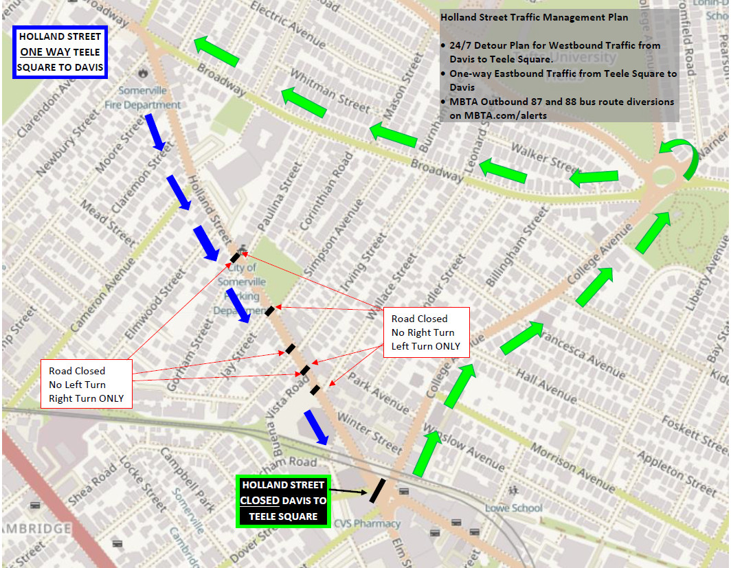
Construction is already underway, having commenced on Monday, October 17, shortly after the plan’s approval, weather permitting. The initial phase focuses on installing three raised crosswalks, a crucial safety enhancement element of the Holland Street project. This phase necessitates a temporary road closure on Holland Street westbound, specifically from Elm to Broadway, and is expected to last for one to two weeks.
During this period, significant traffic adjustments will be in place:
- Westbound Closure: Holland Street westbound, stretching from Davis Square to Teele Square, will be fully closed to traffic 24/7. Westbound motorists and cyclists will be directed to a detour route via College Ave. and Broadway. Detailed detour information can be found here.
- Eastbound Access: Holland Street eastbound will remain open, ensuring continued access in the opposite direction.
- Public Transportation: MBTA bus routes 87 and 88 will operate with modified schedules to accommodate the construction. Passengers are advised to check mbta.com/bus for the most up-to-date service information.
To stay informed about the construction progress and any potential updates, residents are encouraged to subscribe to City Alerts for notifications via email, phone, or text. Alternatively, keep visiting the city website for ongoing updates.
For any queries or concerns related to the construction, please contact [email protected] or reach out to the Engineering Division at (617) 625-6600 ext. 5400.
 Detour map for Holland Street westbound closure during construction in Somerville.
Design Highlights of the Holland Street Safety Plan
The approved design for the Holland Street Safety Update Plan encompasses several key features tailored to different segments of the street, ensuring a cohesive and comprehensive safety upgrade from Teele Square to Davis Square.
 Design plan for Holland Street from Teele Square to Claremon Street showing protected bike lanes and parking.
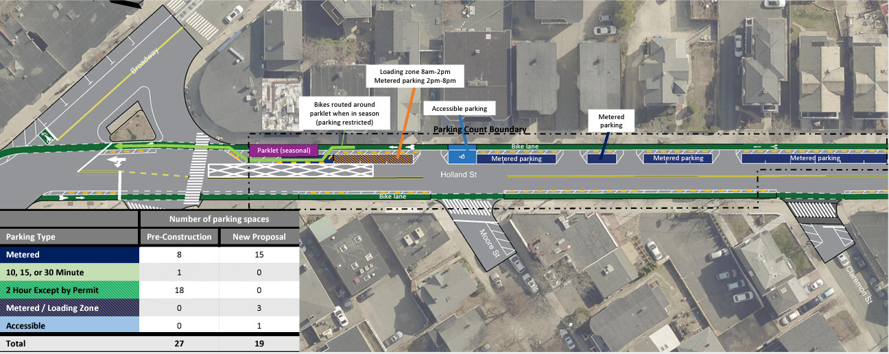
Teele Square to Claremon Street: In this section of Holland Street, the design preserves parking on the north side of the street. Parking is positioned seven feet from the curb, creating space for a westbound protected bike lane directly adjacent to the curb. This design also accommodates seasonal outdoor dining, where parklets can be placed at the curbside during operation, with the bike lane rerouting around them. During winter months when parklets are removed, the bike lane occupies the curbside. Parking provisions are planned to include a mix of commercial loading zones, accessible parking, metered parking, and overnight resident parking.
 Design plan for Holland Street from Claremon Street to Elmwood Street with traffic islands and expanded bus stop.
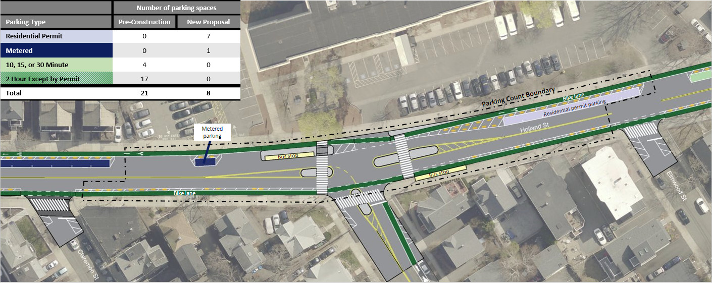
Claremon Street to Elmwood Street: Similar to the previous segment, parking is maintained on the north side and restricted on the south side of Holland Street. A westbound protected bike lane runs along the curb on the north side, while an eastbound protected bike lane is also incorporated, heading towards Davis Square. Pedestrian-focused traffic islands and an expanded bus stop have been implemented at the intersection of Holland Street and Cameron Avenue, further enhancing safety and accessibility. Parking in this section will be a combination of metered parking and resident permit parking.
 Design plan for Holland Street from Elmwood Street to Simpson Avenue showing curb extensions and raised crosswalks.
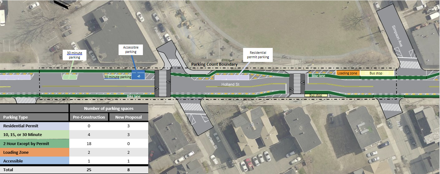
Elmwood Street to Simpson Avenue: Parking configuration remains consistent, with parking on the north side and restrictions on the south side of Holland Street. Westbound and eastbound protected bike lanes are featured. Pedestrian-focused curb extensions have already been constructed at the Paulina Street and Hodgkins-Curtin Park crossings. New raised crosswalks are planned for implementation across Holland Street at Paulina Street and at the Hodgkins-Curtin Park crosswalk. North side parking in this segment is planned to include accessible parking, commercial loading zones, 30-minute parking, and resident permit parking.
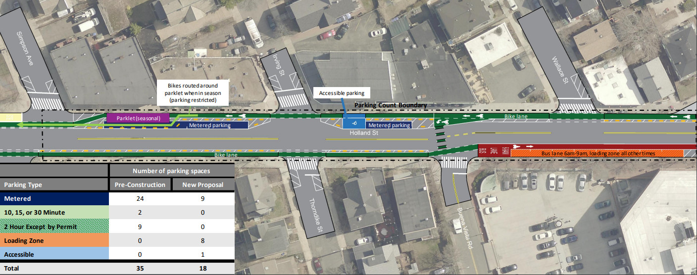 Design plan for Holland Street from Simpson Avenue to Wallace Street with parklets and loading zone.
Simpson Avenue to Wallace Street: Continuing the pattern, parking is on the north side, restricted on the south. Protected bike lanes for both directions are included. This section also considers seasonal parklets; when in use, outdoor dining will remain at the curbside with the bike lane tapering around it. Parking on the north side will be a mix of metered and accessible parking. An eastbound loading zone and a morning peak hour bus lane are planned opposite Wallace Street.
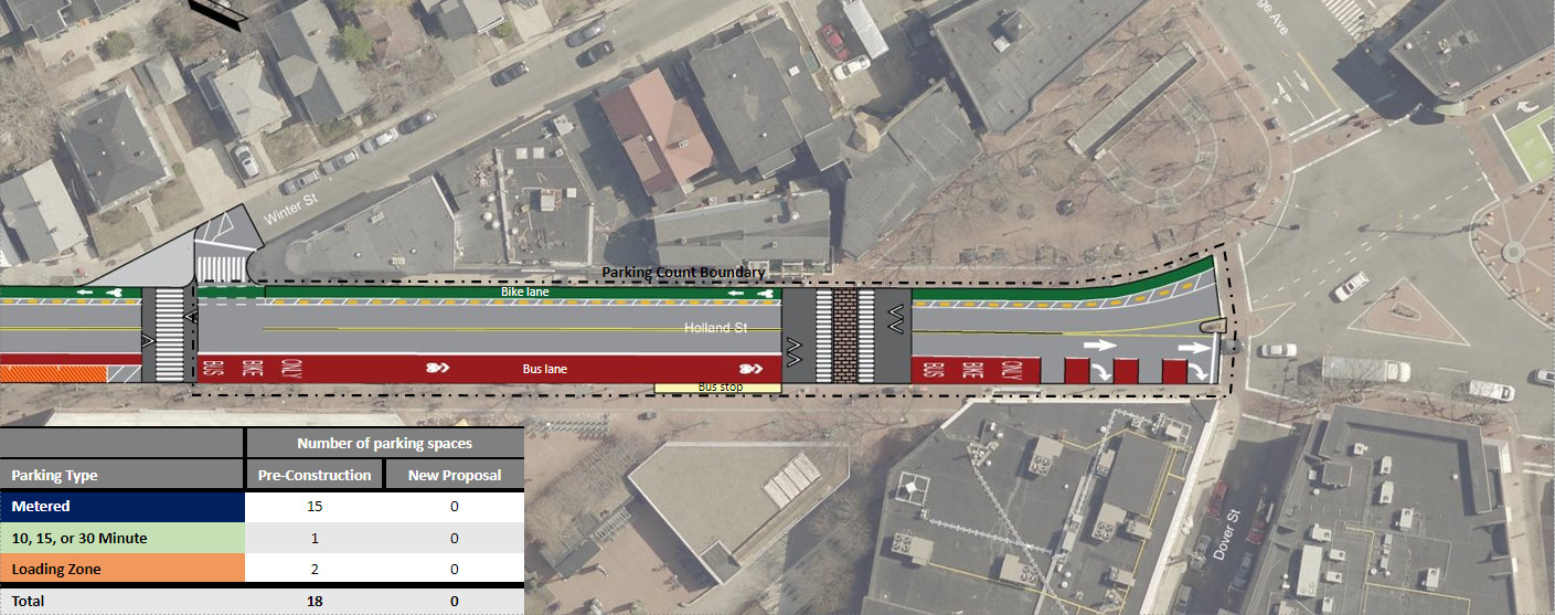 Design plan for Holland Street from Wallace Street to Davis Square with bus and bike lane.
Wallace Street to Davis Square: This final segment of Holland Street will feature a large loading zone for passenger and commercial vehicles, along with a peak hour bus lane eastbound from Buena Vista Road to Winter Street. From Winter Street to Davis Square, this will transition into a 24/7 bus and bike lane. New protected bike lanes will run along the north side. To compensate for parking adjustments on Holland Street, the City has added new loading zones and parking meters on side streets to provide alternative loading and short-term parking options.